Japan faces an intensifying weather crisis as its meteorological agency issued critical warnings Friday of an imminent typhoon strike set to make landfall over the weekend, with simultaneous concerns over a second tropical cyclone bearing down on the nation. The dual threat comes as torrential rainfall already hammers western and eastern prefectures, creating dangerous conditions that have prompted authorities to implement unprecedented evacuation measures affecting millions of residents across a broad geographical swathe of the country.
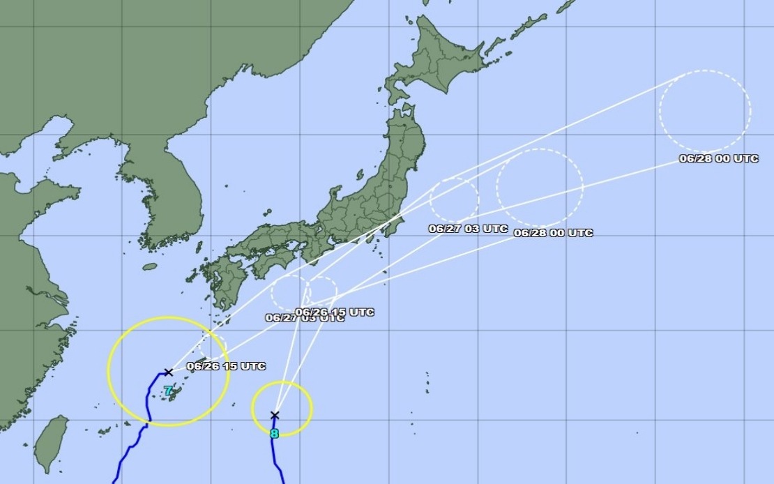
Typhoon Higos represents the more immediate concern, with the Japan Meteorological Agency projecting its approach from the Pacific Ocean toward landfall within 24 hours. Running parallel to this primary threat, Typhoon Mekkhala has already begun impacting southwestern regions, having reached the Amami area in Kagoshima Prefecture on Friday morning. The agency's trajectory modelling suggests Mekkhala will subsequently shift its course toward the densely populated Kanto region, home to Tokyo and surrounding metropolitan areas, compounding the weekend's hazards.
The human toll of the advancing storms has already become evident. The Fire and Disaster Management Agency reported that as of Friday morning, over 2 million individuals across 13 prefectures spanning the Kinki and Kyushu regions had been placed under formal evacuation orders. This massive displacement reflects authorities' assessment that the combination of rainfall, wind, and geological vulnerability poses acute risks. In Seika, Kyoto Prefecture, local government officials activated the highest-level emergency safety alert for affected sections of the municipality after a landslide occurred during Friday morning, underscoring the terrain's instability and the immediate danger facing inhabitants in hilly and mountainous zones.
Rainfall accumulated during the preceding days has already reached alarming levels across multiple locations. The Goto area in Nagasaki Prefecture recorded 600 millimetres of precipitation between Tuesday and Friday morning—equivalent to a month's worth of rain compressed into four days. Similarly, the Aso region in Kumamoto Prefecture and Ureshino in Saga Prefecture each experienced over 500 millimetres during the same period, conditions that saturate soil and dramatically increase landslide probability.
The meteorological agency's forecasts indicate conditions will deteriorate significantly as weekend approaches. Strong storms are expected to impact Okinawa Prefecture and eastern Japan, with particular intensity anticipated in the Tokai and Kanto regions as Typhoon Higos advances northward along the country's southern coast. Rainfall is projected to intensify through Saturday, potentially amplified by the concurrent movement of Typhoon Mekkhala into these same areas. The Tokai region faces potential accumulation of up to 300 millimetres by noon Saturday, while the Kanto-Koshin zone is forecast to receive approximately 150 millimetres, maintaining hazardous conditions for an extended period.
As of Friday late morning, Typhoon Mekkhala was positioned northeast of Kume Island off Okinawa's coast, moving northeastward at a velocity of 15 kilometres per hour. This measured pace means the storm will maintain its disruptive influence across multiple prefectures throughout the weekend period, preventing any rapid improvement in conditions. The Japan Meteorological Agency has indicated that both typhoons are expected to eventually weaken into extratropical cyclones, though this transformation will occur only after the most dangerous impacts have transpired.
For Malaysian and broader Southeast Asian observers, Japan's current meteorological crisis carries instructive implications regarding tropical cyclone preparedness and early warning systems. The sheer scale of evacuation—affecting over 2 million people—demonstrates how modern nations with sophisticated infrastructure and resources mobilize in response to natural hazards. Japan's experience underscores that even technologically advanced countries face genuine vulnerabilities to extreme weather, particularly when multiple systems interact within tight geographical proximity.
The mountainous terrain that characterises much of Japan, particularly across Kyushu, creates additional complexity. Unlike flat regions where flooding represents the primary concern, Japan's landscape demands equal attention to landslide risk, a hazard that becomes acute when rainfall exceeds saturation thresholds. The Seika precedent—an actual landslide occurring even before typhoon impact—illustrates how cascading environmental failures can compound initial weather impacts, a pattern relevant to similar geography across Southeast Asia including parts of Malaysia's east coast and highland regions.
For stakeholders monitoring Japanese economic activity, the typhoon disruption occurs at a time when the region's economy remains sensitive to supply-chain interruptions and transportation delays. The Tokai region encompasses significant industrial and manufacturing zones, meaning Saturday's anticipated heavy rainfall could affect production schedules, logistics networks, and commercial operations. The dual-typhoon scenario creates uncertainty that extends beyond the immediate weather event, potentially influencing market sentiment and economic planning for subsequent weeks.
Authorities have urged the public to maintain heightened vigilance regarding landslide and flooding risks even as both typhoons weaken into extratropical systems. This guidance reflects understanding that storm weakness does not necessarily correlate with hazard elimination; saturated terrain and swollen waterways remain dangerous long after wind speeds diminish. The precautionary messaging from Japan's meteorological establishment provides a template for regional authorities elsewhere, emphasising that public safety communications should address post-storm risks equally with the initial weather event.