Malaysia's sophisticated hydrographic capabilities have emerged as a cornerstone of maritime security in the Strait of Malacca, one of the globe's most strategically vital waterways. Officials from the National Hydrography Centre underscored in Port Klang that the country's technical expertise and infrastructure are fundamental to preserving both the safety of vessels transiting the narrow passage and the principle of freedom of navigation that underpins international maritime law.
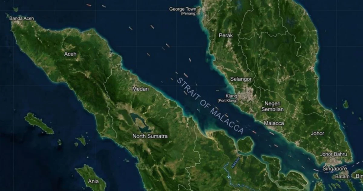
The Strait of Malacca, squeezed between Malaysia and Indonesia for over 500 miles, constitutes one of the world's most important shipping corridors. Approximately one-third of all international maritime trade passes through these compressed waters annually, generating economic value that ripples across global supply chains. For regional economies, particularly Malaysia's, the strait's continued viability as a secure passage is not merely a matter of commercial interest but a fundamental pillar of national prosperity and regional stability.
Hydrography—the scientific study and mapping of water bodies, underwater terrain, and maritime conditions—has traditionally been relegated to the margins of public discourse about maritime security. Yet its importance cannot be overstated. Accurate charts, depth measurements, and current predictions are prerequisites for safe navigation, especially in congested waters where the margin for error is razor-thin. The National Hydrography Centre serves as Malaysia's custodian of this critical knowledge, maintaining and updating the detailed maritime information upon which international navigation depends.
The centre's mandate extends beyond simple cartography. Modern hydrographic work encompasses the detection of hazards, the monitoring of dynamic underwater conditions, and the provision of real-time data that assists vessel operators in making informed routing decisions. In the Strait of Malacca, where hundreds of vessels compete for passage daily, such precision becomes a matter of preventing collisions, protecting the marine environment from catastrophic spills, and maintaining the orderly flow of global commerce.
Malaysia's geopolitical positioning gives it singular responsibility in this domain. As a coastal state bordering the strait, the country possesses both the legal authority under international maritime law and the practical ability to survey and monitor its waters. This dual advantage translates into genuine influence over regional maritime governance and safety standards. The National Hydrography Centre thus functions not merely as a technical service provider but as a guardian of maritime order in one of Asia's most congested shipping lanes.
The implications of this role extend far beyond Malaysia's immediate interests. The strait's security directly affects the economic performance of China, Japan, South Korea, and other major trading nations that depend on uninterrupted access to Middle Eastern oil and African resources. Conversely, any disruption—whether caused by piracy, natural disaster, or navigational failure—would reverberate through regional and global supply chains. The hydrographic capabilities that Malaysia maintains thus represent a public good of international proportions, benefiting maritime commerce across cultural and economic boundaries.
Recent global developments have heightened the significance of Malaysia's hydrographic infrastructure. Piracy concerns in certain regions, the proliferation of larger container vessels that require deeper, more carefully charted passages, and the growing frequency of severe weather events have all intensified demand for accurate maritime information. Climate change, too, presents challenges as rising sea levels and altered current patterns gradually reshape the physical contours of the strait. Malaysia's commitment to maintaining cutting-edge hydrographic surveys becomes increasingly vital in this evolving context.
The technical sophistication required for modern hydrographic work demands substantial investment in equipment, training, and institutional capacity. The National Hydrography Centre maintains specialized vessels, advanced sonar systems, and skilled personnel capable of generating the high-resolution charts and data that contemporary maritime transportation demands. This investment reflects Malaysia's recognition that technological competence in this domain constitutes strategic advantage and responsibility.
Cooperation with international maritime organizations, including the International Maritime Organization, represents another dimension of Malaysia's hydrographic role. By maintaining internationally recognized standards and sharing relevant data with regional partners, Malaysia contributes to a system of maritime governance that transcends national boundaries. The alignment of Malaysian hydrographic practices with global best practices ensures that vessels from all nations can transit the strait with confidence in the accuracy of available information.
Looking forward, Malaysia's hydrographic capabilities will likely become even more central to regional maritime security. Increasing vessel traffic, evolving climate conditions, and persistent security challenges in some maritime zones all point toward heightened demand for the precise, authoritative information that hydrographic institutions provide. The National Hydrography Centre's work, though often invisible to the general public, remains indispensable to the functioning of the global maritime system and, by extension, to prosperity throughout Southeast Asia and beyond.