The ground convulsed without warning on June 8, and when residents of Mindanao's southern coast emerged from their homes, they discovered nature had redrawn the map. What had been familiar shorelines for generations of fishing families had vanished beneath walls of exposed coral and freshly emerged seabed. Arsenio Butil Jr., a pastor and fisherman in Sarangani province's Glan municipality, dropped to his knees in prayer as the 7.8-magnitude quake struck. When he looked up, the world around him was transforming in real time—submerged underwater terrain pushing dramatically above the waterline in what scientists term coastal uplift, a phenomenon born from the violent collision of tectonic plates kilometres beneath the surface.
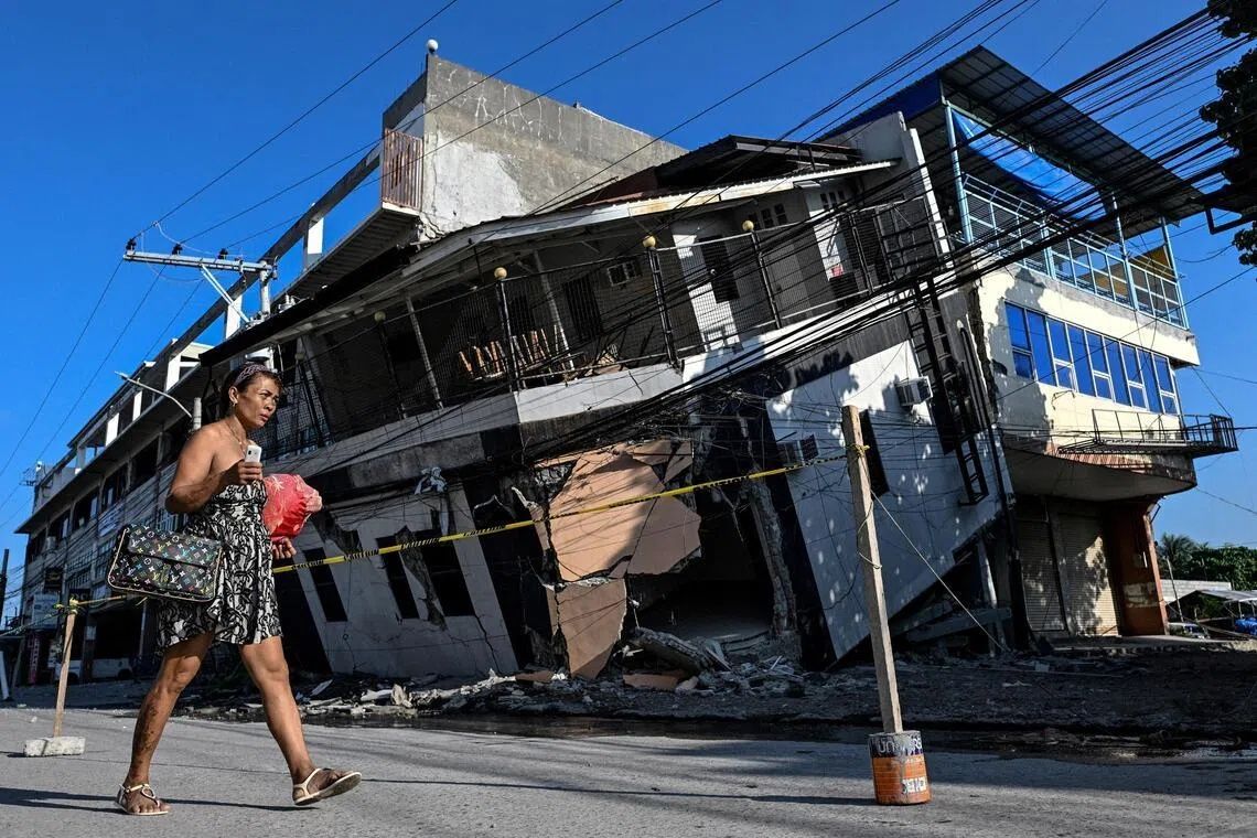
The devastation was immediate and widespread. The June 8 earthquake, triggered by a sudden shift along the nearby Cotabato Trench, levelled buildings across Mindanao, unleashed landslides that buried entire communities, and claimed at least 76 lives. Yet beyond the human toll lay another kind of upheaval: the physical restructuring of the island's very edge. Entire stretches of coastline became unrecognisable to the people who had lived beside them their entire lives. Journalists who visited the region in the quake's aftermath observed fishing boats that once rested at the water's edge stranded on the wrong side of jagged coral formations extending for kilometres in both directions—vessels rendered inaccessible by the sudden geological transformation.
Nane Danlag, a researcher at the Philippines Seismology and Volcanology Center, provided precise measurements of the upheaval. The seabed had risen approximately two metres, she explained, extending the shoreline by as much as 200 metres in certain locations. The affected zone stretched between two towns nearly 100 kilometres apart, representing one of the most dramatic coastal transformations in recent Philippine history. Danlag emphasised that this change was permanent and final. The new coastline, she stated, would remain as the baseline geography for future generations—barring another major tectonic event. She underscored that such movements were not aberrations but rather a continuation of geological processes that have been shaping the region for millennia, though typically at far slower rates.
The Cotabato Trench, which runs as close as 50 kilometres offshore from Mindanao, sits at the intersection of several major tectonic plates and has been a focal point of seismic anxiety for scientists monitoring the region. In January, researchers detected thousands of small earthquakes—a phenomenon known as a seismic swarm—clustered around the trench. A United Nations disaster risk reduction report issued in mid-May raised alarms that these tremors could herald a larger event, a prediction that proved tragically prescient. The June 8 quake was not an isolated incident; since then, more than 8,500 aftershocks have rippled through the region, keeping residents in a state of perpetual tension and uncertainty about whether another major shock might follow.
The human consequences of the uplift extend far beyond property damage. In the hills above a neighbouring village, approximately 100 fishermen and their families remain encamped on higher ground, afraid to return to their destroyed homes in the flatlands below. Datu Atom Malimpnig, a Maguindanaon chieftain representing the displaced group, articulated their deepest fear: that the lifted seabed might represent only the first stage of a catastrophic event. If the sea were to surge forward with a wave triggered by further tectonic movement, it could overwhelm communities that had previously felt safe at sea level. Government aid workers distributed rice porridge to the evacuees even as they waited for official guidance about whether it would ever be safe to rebuild. The psychological toll of displacement compounds the physical losses—homes destroyed, livelihoods disrupted, and faith in the stability of home shattered.
The economic ramifications extend beyond subsistence fishers struggling to recover. Isla Jardin del Mar, a resort that had marketed itself on the promise of pristine white sand beaches and accessible swimming waters, now faces a fundamentally altered business model. Edzel Baylon, who works at the facility, described the bitter irony: the resort's primary attraction—easy access to deep, swimmable waters—had been eliminated by the same tectonic forces that created the disaster. The newly exposed coral and shallow waters now separated guests from the sea they had paid to enjoy. What had been an idyllic beachfront destination had become economically unviable almost overnight. The resort sector, which contributes significantly to Mindanao's tourism economy and provides employment for thousands across the region, faces uncertain recovery prospects in affected areas.
Butil Jr. reflected on the sheer power of the June 8 quake, describing it as the most violent seismic event he had experienced in his lifetime. He recounted the sensations with vivid detail: the water receding from shore, then returning, then receding again in a pattern repeated three or four times. Fish died and floated in the churning waters. The visual and sensory experience left residents traumatised and acutely aware of the fragility of their existence in a geologically unstable region. His observations aligned with scientific understanding of how large earthquakes can trigger temporary sea level fluctuations as the ocean attempts to equilibrate after sudden changes to the seafloor topology.
The question of rebuilding remains unresolved weeks after the initial shock. Butil Jr. and other residents in Glan observe that the ground remains extensively cracked, with fissures running deep and long through the affected terrain. These physical scars suggest that the geological stress has not fully dissipated. The risk calculus for residents is straightforward but devastating: another earthquake of comparable magnitude striking ground already weakened by the June 8 event could prove catastrophic. Rather than rushing to reconstruct destroyed homes, families are choosing to wait, to monitor, to assess whether the region has entered a new equilibrium or whether more violent upheaval lies ahead. The recovery process, typically a matter of months or years following natural disasters, has instead become indefinite.
The June 8 earthquake and its aftermath illustrate the vulnerability of coastal communities in the Western Pacific Ring of Fire. Mindanao's geography—situated along a convergent plate boundary—guarantees ongoing seismic activity. Yet the permanent coastal uplift demonstrates that major earthquakes produce changes that fundamentally alter the relationship between communities and their environment. For fishers, the new coastline means relearning the depths, navigation routes, and fishing grounds they knew instinctively. For resort operators, it means economic losses that may prove unrecoverable. For scientists, it confirms the power of tectonic forces and the necessity of improved early warning systems and hazard preparedness. The landscape has changed irrevocably; now the question is whether the people affected can adapt quickly enough, and whether governments can provide support adequate to the scale of the transformation.