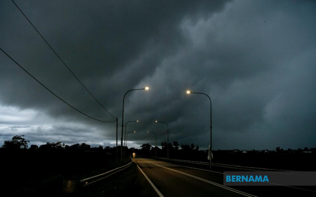
The Malaysian Meteorological Department issued a sweeping weather alert on Tuesday affecting nine states and the federal territory of Labuan, cautioning residents to prepare for thunderstorms, torrential downpours and potentially dangerous wind gusts lasting until 9 pm. The simultaneous warnings across such a broad geographic area underscore the developing nature of the weather system and signal the importance of public awareness during this period of atmospheric instability.
In the northern peninsula, the entire state of Perlis faces the hazardous conditions, whilst Kedah's exposure is concentrated in its northern and central districts including the island of Langkawi, along with towns such as Kubang Pasu, Kota Setar, Pokok Sena, Padang Terap, Sik and Baling. Perak's vulnerable zones stretch across its coastal and interior regions, encompassing Kerian, the Larut and Matang districts, Selama, Kuala Kangsar, Kinta and Kampar, indicating that both seasoned communities and developing areas require heightened vigilance.
The central peninsula has not escaped the system's reach. Pahang's upland Cameron Highlands region, known for its already wet climate and elevation-related weather patterns, sits under warning, as do the flatter districts of Bentong, Bera and Rompin in the state's southern expanse. Selangor's Hulu Langat division, home to numerous residential areas and water catchment zones that feed the capital region, is particularly significant given its proximity to Kuala Lumpur and its importance to urban water supplies. The warning's extension into Negeri Sembilan's Jelebu and Jempol areas further illustrates how the system's influence stretches across the highland spine that divides the peninsula's eastern and western slopes.
Southern Peninsular Malaysia faces parallel threats in Johor, where the Segamat, Kluang and Mersing districts have been flagged for the same hazardous weather. This geographic spread—from the developed urban corridors of Selangor and Negeri Sembilan to the rural and semi-rural zones of Johor's interior—demonstrates the system's potency and the varied communities that require preparedness measures appropriate to their circumstances.
The warnings extend significantly into Malaysian Borneo, where the wet season dynamics create different meteorological patterns than those of the peninsula. In Sarawak, the affected areas form a chain along both the coastal and interior regions: Kuching division encompasses both the Bau area and the state capital itself, whilst Serian to the south, and Samarahan division with its Samarahan and Asajaya zones, represent the western and southwestern approaches to the capital. Moving eastward, Sarikei's Meradong area, the Sibu division, and Mukah's Tanjung Manis enclave face identical conditions. Further inland, Kapit division's Song and Kapit areas, followed by Bintulu division's Tatau and Sebauh, extend the warning across Sarawak's lengthy coastline. Miri division's Marudi area and Limbang round out the Sarawak contingent, indicating that nearly the entire state has been placed under alert.
Sabah's vast territory is similarly affected, with particular concern in the interior regions of Sipitang, Kuala Penyu, Beaufort and Tambunan, as well as the entire west coast corridor and the eastern Sandakan division's Tongod and Kinabatangan areas. The extension into Sabah's interior demonstrates how such weather systems can penetrate deep inland, potentially affecting agricultural areas, logging operations, and rural communities that may have limited real-time communication with meteorological services.
For Malaysian residents in these affected regions, the warning carries practical implications spanning multiple sectors. Motorists should exercise extreme caution on highways where sudden wind gusts and reduced visibility from heavy downpours create hazardous driving conditions, particularly in areas where rainfall could accumulate rapidly. Agricultural communities, especially those in Pahang's highlands and across Sarawak and Sabah, should secure livestock and ensure drainage systems are functioning adequately to prevent waterlogging of crops and erosion of topsoil.
The evening deadline of 9 pm provides a defined timeframe for preparation, though residents should monitor updates from MetMalaysia as weather systems can evolve. For the East Malaysian states, timing considerations become crucial given the distances involved and the potential for isolated communities to experience severe impacts with limited immediate assistance available. Coastal areas in both the peninsula and Borneo might experience localized flooding or temporary disruptions to maritime transport, whilst elevated regions could see increased landslide risks if soils become saturated.
This broad-based warning reflects the meteorological department's commitment to advance notification, allowing residents, local authorities, and emergency services adequate opportunity to implement protective measures. The coordination of warnings across peninsular and East Malaysian states demonstrates the integrated approach now characterised by Malaysia's weather monitoring capabilities, a significant improvement from earlier decades when such distributed alerts were less coordinated.
Residents in these zones are advised to monitor official MetMalaysia bulletins regularly, secure outdoor items that could become projectiles in strong winds, avoid unnecessary travel in the affected areas during the warning period, and ensure families have access to shelter and emergency supplies. Schools, administrative offices and commercial establishments should likewise prepare for potential disruptions to normal operations and ensure that vulnerable individuals—the elderly, young children, and those with health conditions—receive appropriate attention.